In early January, a drone that flew from South Korea into North Korean territory went undetected by our military, raising ongoing concerns about gaps in military surveillance systems.
Military experts, however, point out several challenges in addressing this issue quickly. The current surveillance system is primarily focused on monitoring North Korea, making it difficult to detect drones flying northward from the South. Additionally, civilian drones often operate at very low altitudes and are frequently constructed from materials like Styrofoam, which have high laser transmittance, making them challenging to detect on military radar.
Military Struggles to Balance North and South Surveillance
During a State Council meeting at the Blue House on Tuesday, President Lee Jae Myung expressed concern over the military’s failure to properly identify civilian drones crossing the Military Demarcation Line (MDL). He called for immediate improvements to facilities and equipment.
President Lee reprimanded Defense Minister Ahn Gyu-back, stating that based on what it knows, civilians have recklessly sent drones into North Korea, which is tantamount to an act of war. Despite our improved defense capabilities, it has failed to track these drone movements.
North Korea has demanded an apology, claiming that South Korean drones invaded its airspace in September last year and again on January 4, capturing images of sensitive areas including uranium mines, sedimentation tanks, the Kaesong Industrial Complex, and border outposts. A joint military-police task force is currently investigating suspects, including a graduate student who claimed responsibility for launching a drone and an associate who allegedly constructed it.
In response to the president’s directives, the military has initiated efforts to develop improvement plans. However, analysts suggest that given the current state of military surveillance assets and operational systems, preemptively identifying civilian drones flying from South to North Korea will remain challenging.
The military currently employs a combination of air defense radar, Thermal Observation Devices (TOD), and personnel at observation posts to monitor the border area. However, due to manpower allocation, the potential for conflict, and operational priorities, most key reconnaissance equipment is focused on monitoring North Korea rather than detecting southbound drones. To effectively detect northbound drones, the military would need to either reduce its North Korea monitoring assets or deploy additional personnel and equipment.
A military source explained that its surveillance systems operate complementarily based on target altitude and distance. Currently, its top priority is identifying aircraft flying from North to South Korea.
Low-Altitude Flight and Material Composition Hinder Detection
The low-altitude flight patterns of civilian drones, often referred to as very low altitude, pose a significant challenge for military detection. Radar systems designed to identify fighter jets, bombers, and high-altitude missiles are less effective at capturing objects flying at lower altitudes.
The military typically installs radar equipment at high elevations due to the mountainous border terrain, which is effective for detecting North Korea’s strategic assets like high-altitude missiles but less so for identifying drones. North Korea’s General Staff reported that the civilian drones entering their territory in September and January flew at altitudes between 328 and 984 feet (about 100 to 300 meters). The rugged landscape creates numerous blind spots, further complicating the detection of low-flying drones.
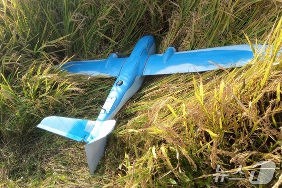
The small size and lightweight materials used in most civilian drones, such as Styrofoam, make them even harder to detect with military equipment. While air defense radar can easily identify flying objects over 6.6 feet (about 2 meters) long, it struggles with smaller targets. This is due to the use of Radar Cross-Section (RCS) for aircraft recognition, where higher transmittance materials result in lower detection probability.
Military radar systems are calibrated to display only aircraft with RCS values meeting certain thresholds, distinguishing between less critical objects like birds and balloons and potential threats. While metal-based air defense weapons are detectable due to their low light transmittance, materials like Styrofoam or plastic often fail to meet RCS standards, evading detection. North Korean photos suggest the drone in question was a small craft with a wingspan of around 6.6 feet (about 2 meters), likely constructed from Styrofoam.
The recent surge in civilian drone usage and the dual-response system further complicate effective military monitoring. Military authorities report that civilian drone flights have skyrocketed from thousands annually to over 10,000 last year.
The Integrated Defense Act allows for supervised drone flights over critical national infrastructure and security facilities by active-duty military personnel. However, for drone activity reported in general areas or near military bases, police are responsible for initial response and action. This division of responsibility limits the military’s ability to comprehensively track civilian drone activity. The Ministry of National Defense plans to enhance its monitoring systems and develop new countermeasures once the joint military-police task force concludes its investigation.