Evidence has emerged of damage in North Pyongan Province, which suffered severe flooding last year, with newly constructed homes collapsing due to heavy rains this year. Observers suggest that the Yongbyon nuclear facility, a key site for North Korea’s nuclear development, may also have been affected.
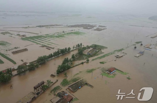
On Thursday, NK News reported landslides and river flooding in Kujang and Yongbyon counties in North Pyongan Province, based on satellite images taken by the private company Planet Labs on July 26.
Korean Central Television reported on July 22 that Kujang County received 329.8 mm (about 13 inches) of rainfall, while Yongbyon County saw 275.6 mm (about 11 inches).
Satellite imagery indicates that Kujang County experienced the most significant damage. The newly constructed homes in Sanggi-ri, which were heavily promoted by Korean Central Television last April, appear to have been affected.
While homes were identifiable in satellite images taken on July 9, photos from July 26 show flooded rivers and debris covering the area, making it difficult to locate the houses.
Moreover, signs of landslides have been detected near the Yongbyon nuclear facility in North Pyongan Province. Although the reactor site itself appears unscathed, there are concerns that the new nuclear facility building identified by the International Atomic Energy Agency (IAEA) may have been damaged.
The IAEA previously reported that North Korea had been bolstering its nuclear capabilities by constructing new facilities at the Yongbyon nuclear complex.
NK News explained that satellite images taken four days after the heavy rains show structures being removed from what is suspected to be the new nuclear facility. This suggests the building may have sustained irreparable damage due to flooding.
Last summer, severe rains caused the Yalu River to overflow, inundating over 400 homes and roads in North Pyongan and Jagang Provinces, resulting in significant casualties.
As of now, North Korea has not disclosed the extent of damage caused by this year’s heavy rains.


